Europe, a Decade Shaped by Wildfires
- Mireia Camacho
- Data visualization
- August 2, 2026
Summer usually brings sunny weather, beach days and holidays, but it also comes with droughts and heatwaves. These conditions create the perfect environment for a small ignition to develop into a wildfire.
According to the European standard, the wildfire season runs from 1 June to 30 September. However, rising temperatures and prolonged droughts are causing large wildfires to extend well beyond the summer months.
Europe has gone from dealing with 1,194 wildfires in 2016 to 10,403 in the first six months of 2026 alone.

The number of wildfires in Europe has continued to rise over the past decade. The sharpest increase occurred between 2021 and 2022, when the number of wildfires jumped from 6,629 to 12,672; almost doubling in a single year. Since then, the figures have remained well above those recorded at the beginning of the decade.
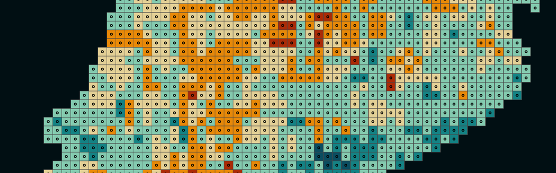
In recent years, wildfires have no longer been confined to the summer months. In particular, February and March 2019, as well as March in 2021, 2022, 2025 and 2026, recorded more wildfires than the summer months of those same years.
It is also worth noting that, as a result of climate change, October is increasingly experiencing temperatures and weather conditions similar to those of September, increasing the likelihood of wildfires comparable to those typically seen during the summer.
One might assume that a higher number of wildfires does not necessarily mean that more hectares (Ha) will burn. And to some extent, that would be true.
In 2020, there were 5,602 wildfires that burned 919,533 ha, while in 2021, despite recording 6,629 wildfires, the burned area was slightly lower, at 919,049 ha. More than 1,000 additional wildfires, yet fewer hectares burned.
Unfortunately, the recent surge in the number of wildfires has also led to a sharp increase in the total area burned, rising from 506,184 ha in 2016 to more than 2 million ha in 2025.
So what is causing so many hectares to burn every year? Most of the burned area is not spread across thousands of small wildfires but is instead concentrated in a relatively small number of large fires.
According to the official standards used in Spain, a Large Forest Fire (LFF) is any wildfire that burns more than 500 hectares of forest land.
With the exception of 2016 and 2017, these large forest fires account for only between 2% and 6% of all wildfires recorded each year. However, they are responsible for more than half of the total area burned in most years.
Total number of wildfires and large forest fires by year
| Year | Wildfires | LFF | Total ha burned | Ha burned by LFFs |
|---|---|---|---|---|
| 2016 | 1,194 | 228 (19.1%) | 506,184 | 352,830 (69.7%) |
| 2017 | 2,733 | 396 (14.5%) | 1,256,594 | 956,759 (76.1%) |
| 2018 | 1,138 | 60 (5.3%) | 198,993 | 102,295 (51.4%) |
| 2019 | 3,299 | 186 (5.6%) | 533,407 | 251,864 (47.2%) |
| 2020 | 5,602 | 282 (5.0%) | 919,533 | 543,127 (59.1%) |
| 2021 | 6,629 | 231 (3.5%) | 919,049 | 597,316 (65.0%) |
| 2022 | 12,672 | 367 (2.9%) | 1,300,001 | 713,738 (54.9%) |
| 2023 | 8,377 | 215 (2.6%) | 804,663 | 433,280 (53.8%) |
| 2024 | 18,391 | 555 (3.0%) | 1,798,548 | 837,800 (46.6%) |
| 2025 | 21,578 | 534 (2.5%) | 2,172,169 | 1,271,969 (58.6%) |
| 2026* | 10,403 | 116 (1.1%) | 471,529 | 158,402 (33.6%) |
* Data up to early July
Especially during summer, it is easy for a small wildfire to grow out of control and become a large forest fire. High temperatures, drought, low humidity and strong winds create the ideal conditions for fire to spread rapidly. In remote areas or rugged terrain, firefighting operations become far more difficult, increasing the likelihood that a wildfire will reach a devastating scale.

Although wildfires are recorded across almost all of Europe, they are not evenly distributed. Copernicus' Fire Weather Index (FWI) estimates wildfire risk based on meteorological data and identifies the areas where conditions are most favourable for large fires to develop.
Since 2016, the overall level of risk has increased slightly, but Mediterranean countries continue to experience the most favourable conditions for wildfire spread every summer and account for the majority of recorded fires.
Even so, each country has shown different wildfire patterns over the past decade, shaped not only by weather conditions but also by factors such as topography and the resources available for firefighting.
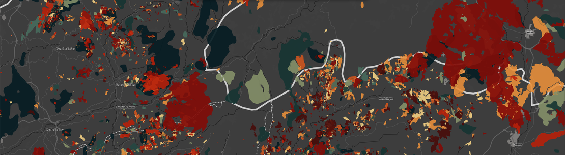
Portugal is one of the European countries most severely affected by wildfires. Burned areas are concentrated in the north and the centre of the country, where the rugged terrain makes it more difficult for firefighters to contain the spread of the flames.
In Spain, wildfires are distributed quite unevenly. The northwestern part of the Iberian Peninsula clearly records the highest level of activity, with an almost continuous chain of fires stretching from Galicia to the Cantabrian coast. Significant wildfire hotspots also occur in western Castile and León, Extremadura, and parts of the Central System mountain range, while the Mediterranean coast experiences fewer and more isolated fires.
Italy is one of the European countries with the highest number of wildfires. Most are concentrated in the south of the peninsula and on the islands of Sicily and Sardinia, where the Mediterranean climate, high summer temperatures, and abundant vegetation favour both ignition and fire spread. By contrast, northern Italy records much lower and more scattered wildfire activity, mainly along coastal regions and in parts of the Apennine Mountains.
The countries along the western Balkan coast display one of Europe's most persistent wildfire patterns. From Croatia to Albania, fires are concentrated mainly along the Adriatic coastline and in the mountainous inland regions, where dry summers, rugged terrain, and dense Mediterranean vegetation favour rapid fire spread. In contrast, the inland plains experience much lower and more scattered wildfire activity.
Wildfires occur throughout Greece, but they are concentrated in the central and southern parts of the country. The regions of Attica, Euboea (Evia), and the Peloponnese experience some of the most frequent wildfire events, together with numerous fires across the Aegean islands.
Hot, dry summers, combined with Mediterranean vegetation and mountainous terrain, allow fires to spread rapidly across many of these areas. As a result, Greece has experienced some of Europe's largest and most devastating wildfires over the past decade, including the largest wildfire ever recorded in the European Union.
Ukraine shows a wildfire pattern unlike that of the rest of Europe. While fires were scattered across different regions of the country until 2021, from 2024 onwards they became heavily concentrated in the east and south, closely following the front line and the border with Russia.
Most of these fires are driven not only by summer weather conditions but also by the direct consequences of the armed conflict. Explosions, shelling, landmines, and ammunition ignite numerous fires that, under conditions of high temperatures and drought, can continue burning for days.
As a result, 2024 became the worst wildfire season ever recorded in Ukraine, with an unprecedented burned area and a wildfire pattern that clearly reflects the advance of the war across the country's territory.
Over the past decade, Europe has experienced a sharp increase in both the number of wildfires and the total area burned. Large wildfires are no longer exceptional events limited to a few particularly dry summers, but increasingly frequent phenomena that begin before summer, continue well into autumn, and affect regions where they were far less common only a few years ago. Rising temperatures, prolonged droughts, and heatwaves are creating increasingly favourable conditions for a small ignition to develop into a large wildfire.
However, climate alone does not explain what is happening. According to the European Commission, climate change acts as a risk multiplier by favouring the spread of wildfires, but it is rarely the cause of ignition. According to a study by the Joint Research Centre (JRC), among the wildfires for which the cause could be determined (around half of all cases), approximately 96% were caused by human activity, either deliberately or through negligence, while only 4% had a natural origin, such as a lightning strike.
Reducing the risk of large wildfires therefore requires action on two fronts. On the one hand, limiting global warming to prevent weather conditions from becoming even more favourable to increasingly extreme wildfires. On the other, strengthening prevention measures, forest management, and public awareness to reduce the number of fires that ignite in the first place. Because although it may not always be possible to prevent a summer from becoming hotter and drier, it is possible to reduce the number of fires that start and, in doing so, limit the impact of wildfires that threaten an ever larger share of Europe's territory every year.
All the content in this article has been created using data from the European Forest Fire Information System (EFFIS).